One of the guys from the Charleston Tech Slack was selling a dual monitor mount, so now my two computer monitors are now mounted off the desk at a much more comfortable working height.
Computer monitors before
One 6mm hex wrench and 8 M4x12mm screws later, the monitors were mounted on the stand and reconnected to power and the computer.
Computer monitors after
It’s a pretty sturdy stand and seems to be holding my 21″ monitors pretty easily. I added an additional piece of 1×4 to where the stand clamps to the table as an additional shim and to help spread the load on the table top a bit more.
The monitors are up about 5 cm higher than they were with the factory stands, and a lot of space underneath the monitors is freed up. Pretty pleased with this setup.
Ventured out to Lowe’s this afternoon while the weather was still decent to pick up a few things, including a small weather monitoring station because we thought it would be interesting to see what the winds were like as Irma started to make its presence known.
Found this basic little Acu-Rite unit that measures wind speed and outdoor/indoor temp and humidity.
Acu-Rite weather station
The outdoor sensor was easy to install using the included mount. Four screws in the top of one of the fence posts and a small set screw to fasten the sensor unit to the mount and you’re done.
Weather sensor module
The display module shows all the information on a display that’s designed to be looked at from slightly above rather than straight on.
Weather station display unit
Seems to be working fairly well so far. Will be interesting to see what kinds of wind speeds we get as Irma gets closer.
After a tense few days of watching Irma and its forecast tracks, some of the effects of Irma are starting to reach us here. The eye of Irma is only just reaching the Florida Keys this morning, so this storm is pretty broad in reach. Pretty much all of Florida is going to be battered up by the hurricane.
Hurricane Irma forecast 201709101200Z
The eastern coast managed to dodge what would have been a pretty catastrophic storm had it followed some of the earlier forecasts, but we’re not out of the woods yet. There are still warnings for strong winds, heavy rain, and flooding from rain and storm surge.
Charleston is already beginning to feel the effects on the periphery of this extremely large hurricane, as a pressure gradient has developed between a strong high pressure wedge centered over the Great Lakes and the very deep low pressure associated with Hurricane Irma. The interaction between the two pressure centers is driving gusty northeast winds across the area, similar to the effect one would feel standing between two large buildings.
The EarthWindMap website offers a pretty nice visualization of winds at different altitudes and lets you step through the GFS model to see how things might change over the model duration.
Wind 20170910 1200UTC
Wind 20170910 2000UTC
Wind 20170911 1200UTC
Wind 20170912 0000UTC
Wind 20170912 0900UTC
For the next couple of days, forecast shows surface winds that will push a lot of water toward the SC coast, causing a fair bit of flooding especially when combined with the already anticipated higher than usual tides.
I’m expecting a lot of rain and pretty windy conditions, but we’re far enough inland so surge related flooding isn’t a big concern. Fortunately the land around our subdivision is still largely undeveloped so there’s plenty of ground around us to soak up the rain water. I expect that will be gone over the next couple of years though, so the flooding probability might change.
Just a few more things to move around so they don’t get blown away, and then we see what Irma brings us.
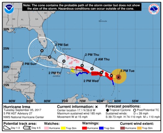
All the weather talk the last few days has been about Hurricane Irma, which is a Category 5 hurricane with 185 mph winds as of the 2017-09-05 2100Z update.
Irma becomes only the fifth Atlantic basin hurricane with a peak wind speed of 160 kt or
higher.  The others are Allen (1980), the Labor Day Hurricane of 1935, Gilbert (1988), and Wilma (2005).
Still a little early to know what kind of weather to expect from Irma in South Carolina, but it looks like Florida will have a good chance of taking a big hit.
Hurricane Irma forecast 201709042100Z
The intensity forecast shows some weakening over the next few days as Irma plows through the islands. Irma is still going to pack a pretty big punch when it reaches Cuba and Florida though.
It will be another two or three days before the forecast track becomes reliable enough to see what will happen here. In the meantime, we’re preparing things to either hunker down or leave depending on what happens with the forecast.