After Irma

The original plan was to have a four day weekend working on projects and binging on Netflix while Connie was away. Instead we got to watch and prepare for a storm. The majority of yesterday was spent dealing with the effects of Hurricane Irma as the storm made its way up Florida and through Georgia.

Here at the house, Irma brought some gusty winds, a fair bit of rain, a few tornado warnings, but no problems with flooding or wind damage.

Other parts of the Charleston area got pretty hammered, especially the peninsula and the coastal areas. High tide yesterday was reported at 9.9 feet (3 m) and there were pictures posted on Twitter of the harbour spilling over the sea wall and filling up White Point Gardens.

Numerous other pictures on Twitter and Facebook showed the epic flooding that happened on the peninsula and other parts of the area.

The iconic Folly boat that got blown ashore during Hurricane Hugo got blown back into the ocean by Irma. It got blown into someone’s dock, and the last I’ve heard so far is that it might be secured to that dock or in someone’s yard ready to be put back where it originally landed.

There were reports of tornado touchdowns in Johns Island and West Ashley, although I haven’t seen any confirmation of those yet. There were confirmed water spouts off the coast of Isle of Palms though, so there was a lot of potential for tornado activity.

Aside from the tornado warnings, everything was going reasonably well until the power went out. Power went out a couple of times so we got to put the new generator to work. The first power outage was around 3 PM and lasted about 4 hours. The second one happened later in the evening (neighbours reported a transformer near the apartments next to us blew up) not long after I put all the extension cords away. I was expecting the power to be out for the rest of the night, but thankfully power was restored a couple hours later. The generator was a bit on the loud side, but it worked great and was easy to start.

Irma proved to be a good training exercise for us. There were a lot of things we did that worked well, and we learned a few things that we’ll do a little differently for next time.

  • Stage the generator on the back porch instead of having to go out into the wind and rain to pull the generator out of the garage
  • Consider having a transfer switch installed to plug the generator into instead of running a bunch of extension cords all over the place.
  • Pack the freezer more to help it maintain temperature.
  • Could use a few more of these flashlights scattered around the house. These come on automatically when wall power disappears and are especially handy when power goes out at night.
  • Have bags and everything we need for the pets packed in case we decide to flee.
  • Skip the tomato flavoured pouches of tuna.

Now to go put all the outside things back where they belong.

Three months left in the hurricane season this year and already halfway through the list of storm names.

Starting to feel some of Hurricane Irma

After a tense few days of watching Irma and its forecast tracks, some of the effects of Irma are starting to reach us here. The eye of Irma is only just reaching the Florida Keys this morning, so this storm is pretty broad in reach. Pretty much all of Florida is going to be battered up by the hurricane.

Hurricane Irma forecast 201709101200Z

The eastern coast managed to dodge what would have been a pretty catastrophic storm had it followed some of the earlier forecasts, but we’re not out of the woods yet. There are still warnings for strong winds, heavy rain, and flooding from rain and storm surge.

Jared’s Medium post has a good summary of what Charleston can expect from Irma.

Charleston is already beginning to feel the effects on the periphery of this extremely large hurricane, as a pressure gradient has developed between a strong high pressure wedge centered over the Great Lakes and the very deep low pressure associated with Hurricane Irma. The interaction between the two pressure centers is driving gusty northeast winds across the area, similar to the effect one would feel standing between two large buildings.

The EarthWindMap website offers a pretty nice visualization of winds at different altitudes and lets you step through the GFS model to see how things might change over the model duration.

For the next couple of days, forecast shows surface winds that will push a lot of water toward the SC coast, causing a fair bit of flooding especially when combined with the already anticipated higher than usual tides.

I’m expecting a lot of rain and pretty windy conditions, but we’re far enough inland so surge related flooding isn’t a big concern. Fortunately the land around our subdivision is still largely undeveloped so there’s plenty of ground around us to soak up the rain water. I expect that will be gone over the next couple of years though, so the flooding probability might change.

Just a few more things to move around so they don’t get blown away, and then we see what Irma brings us.

Prepping for Irma

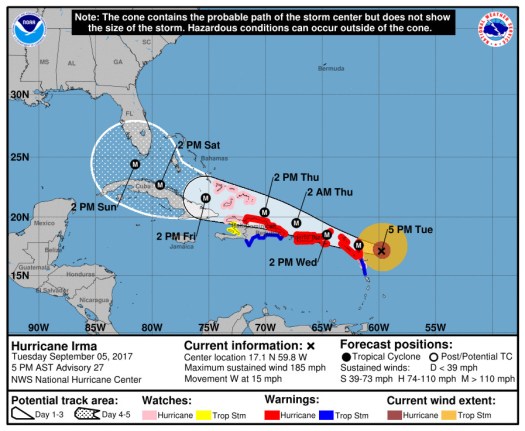
All the weather talk the last few days has been about Hurricane Irma, which is a Category 5 hurricane with 185 mph winds as of the 2017-09-05 2100Z update.

Irma becomes only the fifth Atlantic basin hurricane with a peak wind speed of 160 kt or
higher.  The others are Allen (1980), the Labor Day Hurricane of 1935, Gilbert (1988), and Wilma (2005).

Still a little early to know what kind of weather to expect from Irma in South Carolina, but it looks like Florida will have a good chance of taking a big hit.

Hurricane Irma forecast 201709042100Z

The intensity forecast shows some weakening over the next few days as Irma plows through the islands. Irma is still going to pack a pretty big punch when it reaches Cuba and Florida though.

FORECAST POSITIONS AND MAX WINDS

INIT  05/2100Z 17.1N  59.8W  160 KT 185 MPH
 12H  06/0600Z 17.6N  61.8W  155 KT 180 MPH
 24H  06/1800Z 18.5N  64.6W  150 KT 175 MPH
 36H  07/0600Z 19.5N  67.3W  145 KT 165 MPH
 48H  07/1800Z 20.4N  70.1W  140 KT 160 MPH
 72H  08/1800Z 21.6N  75.3W  135 KT 155 MPH
 96H  09/1800Z 22.7N  79.3W  125 KT 145 MPH
120H  10/1800Z 24.4N  81.5W  120 KT 140 MPH

It will be another two or three days before the forecast track becomes reliable enough to see what will happen here. In the meantime, we’re preparing things to either hunker down or leave depending on what happens with the forecast.