TS Debby

Looks like the week ahead is going to be pretty wet and soggy thanks to TS Debby. Current forecast has it slowing down as it goes through FL and GA and dumping a lot of rain on the area in the process.

Tropical Storm Debby forecast 04-Aug-2024
5 day total rainfall forecast from Tropical Storm Debby 04-Aug-2024

From the 11AM 04-Aug-2024 NHC forecast discussion

After the system makes landfall, the steering currents are likely to weaken as a trough over the northeastern U.S. moves eastward from the area, which should result in a decrease in forward speed.  There is significant uncertainty in the track of Debby in the 2-5 day time frame.  Much of the track guidance keeps the center over the southeastern U.S. for the next several days as a ridge builds in over the Carolinas.

The cyclone will weaken after it moves inland, but since the system will not be far from the coastline for the next few days, it is not predicted to fall below tropical storm strength through 72 hours.

Should be an interesting week ahead.

Tropical Storm Beryl

The second tropical storm of the season, Beryl, looks like one to keep an eye on starting the middle of next week. The forecasts show it becoming a hurricane in another day or so.

National Hurricane Center forecast map for Tropical Storm Beryl
The initial motion is 280/18 kt.  Beryl is on the south side of a 
strong subtropical ridge, and this feature should steer the cyclone 
quickly westward or west-northwestward toward and through the 
Windward Islands during the next 2-3 days. After that time, there is 
some divergence in the track guidance as Beryl approaches a weakness 
in the subtropical ridge near and east of Florida.  The GFS-based 
guidance calls for the storm to continue west- northwestward, while 
the ECMWF and UKMET models show a more westward motion. The 
consensus models lean more toward a west-northwestward motion, and 
the official forecast follows this guidance.  The new forecast track 
has only minor changes from the previous track.

Following behind Beryl is another system that seems likely to turn into another storm to watch in a week or two

An area of low pressure located several hundred miles southwest of 
the Cabo Verde Islands is producing an area of disorganized showers
and thunderstorms. Environmental conditions appear conducive for
additional development of this system, and a tropical depression
could form by the middle of next week while it moves generally
westward at 15 to 20 mph across the eastern and central tropical
Atlantic.
* Formation chance through 48 hours...low...20 percent.
* Formation chance through 7 days...medium...60 percent.

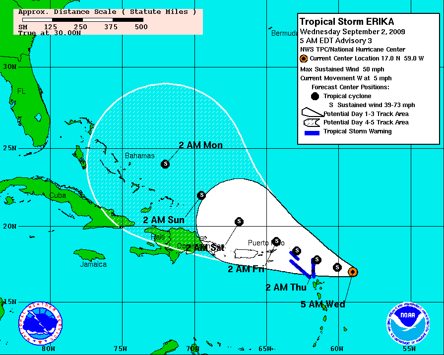
TS Erika

It’s September which means we’re starting to get into the peak of the hurricane season. Yesterday the NHC announced TS Erika had formed but forecast models don’t have it strengthening a whole lot.

DATA FROM THE AIRCRAFT INDICATE THAT ERIKA HAS WEAKENED A LITTLE… WHICH IS NOT SURPRISING CONSIDERING THE DISORGANIZED APPEARANCE OF THE SYSTEM ON SATELLITE IMAGES. MODERATE WESTERLY SHEAR HAS BEEN DISRUPTING THE CYCLONE BUT THE SHEAR IS NOT EXPECTED TO BE STRONG ENOUGH TO PREVENT SOME STRENGTHENING DURING THE NEXT DAY OR SO. THEREAFTER…AN UPPER-TROPOSPHERIC TROUGH FARTHER TO THE WEST IS LIKELY TO IMPART INCREASING SOUTHWESTERLY SHEAR ON ERIKA…WHICH SHOULD INDUCE WEAKENING. THE NHC INTENSITY FORECAST IS VERY SIMILAR TO THE PREVIOUS OFFICIAL FORECASTS…BUT BELOW THE CONSENSUS OF THE NUMERICAL INTENSITY GUIDANCE.

It’ll definitely be something to watch after the weekend when I get back from Dragon*Con.

First named storm of 2007!

Well, this is interesting. The National Hurricane Center has given that storm system swirling off the coast a name, Andrea, making it the first named storm of the season almost a month before the 2007 hurricane season officially starts.

AT 11 AM EDT…1500 UTC…A TROPICAL STORM WATCH HAS BEEN ISSUED ALONG THE SOUTHEAST COAST OF THE UNITED STATES FROM ALTAMAHA SOUND GEORGIA SOUTHWARD TO FLAGLER BEACH FLORIDA. A TROPICAL STORM WATCH MEANS THAT TROPICAL STORM CONDITIONS ARE POSSIBLE WITHIN THE WATCH AREA…GENERALLY WITHIN THE NEXT 36 HOURS.

ANDREA IS MOVING GENERALLY TOWARD THE WEST NEAR 3 MPH. A CONTINUED SLOW MOTION AND A GRADUAL TURN TOWARD THE SOUTHWEST ARE EXPECTED DURING THE NEXT 24 HOURS. ALONG THIS TRACK…THE CENTER OF ANDREA IS EXPECTED TO REMAIN OFFSHORE OF THE U.S. COAST THROUGH AT LEAST THURSDAY MORNING.

According to the National Weather Service radar, there’s a narrow but intense band of rain that looks to be heading our way within the next hour or so, so it looks like it’s going to be a wet afternoon.