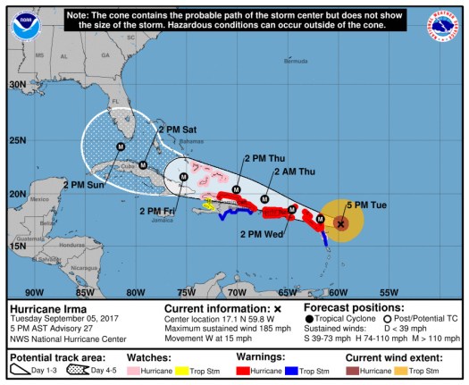
All the weather talk the last few days has been about Hurricane Irma, which is a Category 5 hurricane with 185 mph winds as of the 2017-09-05 2100Z update.
Irma becomes only the fifth Atlantic basin hurricane with a peak wind speed of 160 kt or
higher.  The others are Allen (1980), the Labor Day Hurricane of 1935, Gilbert (1988), and Wilma (2005).
Still a little early to know what kind of weather to expect from Irma in South Carolina, but it looks like Florida will have a good chance of taking a big hit.

The intensity forecast shows some weakening over the next few days as Irma plows through the islands. Irma is still going to pack a pretty big punch when it reaches Cuba and Florida though.
FORECAST POSITIONS AND MAX WINDS

INIT  05/2100Z 17.1N  59.8W  160 KT 185 MPH
 12H  06/0600Z 17.6N  61.8W  155 KT 180 MPH
 24H  06/1800Z 18.5N  64.6W  150 KT 175 MPH
 36H  07/0600Z 19.5N  67.3W  145 KT 165 MPH
 48H  07/1800Z 20.4N  70.1W  140 KT 160 MPH
 72H  08/1800Z 21.6N  75.3W  135 KT 155 MPH
 96H  09/1800Z 22.7N  79.3W  125 KT 145 MPH
120H  10/1800Z 24.4N  81.5W  120 KT 140 MPH
It will be another two or three days before the forecast track becomes reliable enough to see what will happen here. In the meantime, we’re preparing things to either hunker down or leave depending on what happens with the forecast.
Discover more from Imablog
Subscribe to get the latest posts sent to your email.
One Reply to “Prepping for Irma”
Comments are closed.