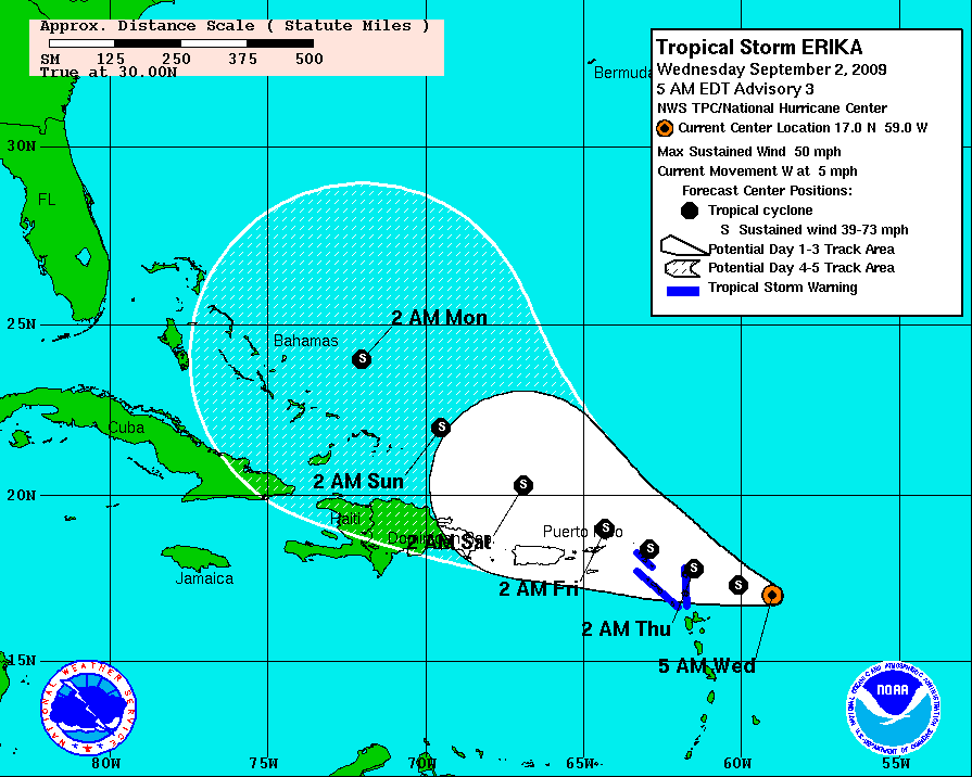
TS Erika

It’s September which means we’re starting to get into the peak of the hurricane season. Yesterday the NHC announced TS Erika had formed but forecast models don’t have it strengthening a whole lot.

DATA FROM THE AIRCRAFT INDICATE THAT ERIKA HAS WEAKENED A LITTLE… WHICH IS NOT SURPRISING CONSIDERING THE DISORGANIZED APPEARANCE OF THE SYSTEM ON SATELLITE IMAGES. MODERATE WESTERLY SHEAR HAS BEEN DISRUPTING THE CYCLONE BUT THE SHEAR IS NOT EXPECTED TO BE STRONG ENOUGH TO PREVENT SOME STRENGTHENING DURING THE NEXT DAY OR SO. THEREAFTER…AN UPPER-TROPOSPHERIC TROUGH FARTHER TO THE WEST IS LIKELY TO IMPART INCREASING SOUTHWESTERLY SHEAR ON ERIKA…WHICH SHOULD INDUCE WEAKENING. THE NHC INTENSITY FORECAST IS VERY SIMILAR TO THE PREVIOUS OFFICIAL FORECASTS…BUT BELOW THE CONSENSUS OF THE NUMERICAL INTENSITY GUIDANCE.

It’ll definitely be something to watch after the weekend when I get back from Dragon*Con.

Storm train

The next couple of weeks are shaping up to be interesting with Tropical storm Ana and Tropical depression 3 following close behind and quite possibly becoming Tropical storm Bill in the next day or so.

What I find interesting is the strengthening forecast. The 5-day forecast for Ana has it remaining a tropical storm until it reaches somewhere near Florida/eastern Gulf of Mexico/Cuba. TD3 however is forecast to become a hurricane by the end of it’s 5-day forecast

Either way it looks like there will be some interesting weather to watch towards the end of the week and into the weekend.

TD2 2009

Just in time for when school starts next week we have the second tropical depression of the season.

FIRST LIGHT VISIBLE SATELLITE IMAGES SHOW THAT THE BROAD LOW PRESSURE AREA ASSOCIATED WITH A TROPICAL WAVE THAT WE HAVE BEEN TRACKING OVER THE FAR EASTERN TROPICAL ATLANTIC HAS ACQUIRED SUFFICIENT ORGANIZED DEEP CONVECTION TO BE DESIGNATED AS A TROPICAL DEPRESSION. THE TROPICAL CYCLONE IS SITUATED OVER MARGINALLY WARM SEA SURFACE TEMPERATURES AND THE VERTICAL SHEAR IS CURRENTLY RATHER WEAK. THE OFFICIAL FORECAST SHOWS GRADUAL STRENGTHENING OVER THE NEXT COUPLE OF DAYS AND IS A BLEND OF THE VARIOUS NUMERICAL GUIDANCE TOOLS. AS USUAL THERE IS CONSIDERABLE UNCERTAINTY AS TO THE STRENGTH OF THIS SYSTEM LATER IN THE FORECAST PERIOD. IF THE CYCLONE MOVES FARTHER NORTH THAN ANTICIPATED BELOW IT WILL PROBABLY ENCOUNTER STRONGER SHEAR AND NOT INTENSIFY AS MUCH AS FORECAST. ON THE OTHER HAND IF THE SYSTEM MOVES FARTHER SOUTH THAN EXPECTED LATE IN THE PERIOD…IT WILL PROBABLY BECOME STRONGER THAN ANTICIPATED HERE.

Mostly normal

NOAA came out with their forecast for the 2009 Atlantic hurricane season a few days ago and said this year should be pretty normal as far as numbers of storms go.

They’ve forecast 14 named storms, 4-7 hurricanes with 1-3 of them being major hurricanes.

Shaping this seasonal outlook is the possibility of competing climate factors. Supporting more activity this season are conditions associated with the ongoing high-activity era that began in 1995, which include enhanced rainfall over West Africa, warmer Atlantic waters and reduced wind shear. But activity could be reduced if El Nino develops in the equatorial Eastern Pacific this summer or if ocean temperatures in the eastern tropical Atlantic remain cooler than normal.

NOAA also retired 4 names from the list of names: Gustav, Ike and Paloma for Atlantic coast and Alma from the North Pacific list.

Hopefully the worst we get here are windy tropical storms that will bring some much needed rain and no hurricanes.